Good puzzle would be cross Dublin without passing a pub. Save it they can’t.
Leopold Bloom posed his famous puzzle in the novel Ulysses as he wandered out to buy a kidney for his breakfast on the 16th June 1904.
Can you cross Dublin without passing a pub? Can you cross it now? Could you cross it in 1904?
In June 2011 Computer Programmer Rory McCann used computers to solve the puzzle. He plotted the locations of the existing public houses and he used algorithms to avoid them.
I decided to solve the same puzzle, but choosing a journey that Joyce or Leopold Bloom would likely have made and using my own set of rules.
The first rule is that the route has to have some relevancy to the writings of James Joyce, and or his actual life in Dublin. This rule pretty much defines all the runs on this website.
I very quickly decided to try to find a route from 5 St.Peter’s Road in Cabra, the Joyce family home on 1904, on the north-west side of the city to 60 Shelbourne Road on the south-east side. I am interested in the Joyce family’s financial decline and its associations with their moving steadily northward through Dublin. As soon as he got a chance, James Joyce moved directly south from the family home to Shelbourne Road.
The second rule is that you actually have to cross Dublin. Skirting the edges of the city is not good enough. Starting outside the city and passing through the centre is ideal.
It would be relatively simple to skirt the city, keeping to the canal or city edges. I decided to run through it. This presents problems as the centre of Dublin has a lot of pubs.
The most fundamental of rules. Passing a pub would be defined as passing by an entrance door to a public house, either on the same side, or on the opposite side of the street.
I decided that although Hotels, Wine Bars and Off Licences are places you can get a drink, they do not count as they are not public houses. I decided to try to avoid them anyway.
Armed with a set off rules I began my game.
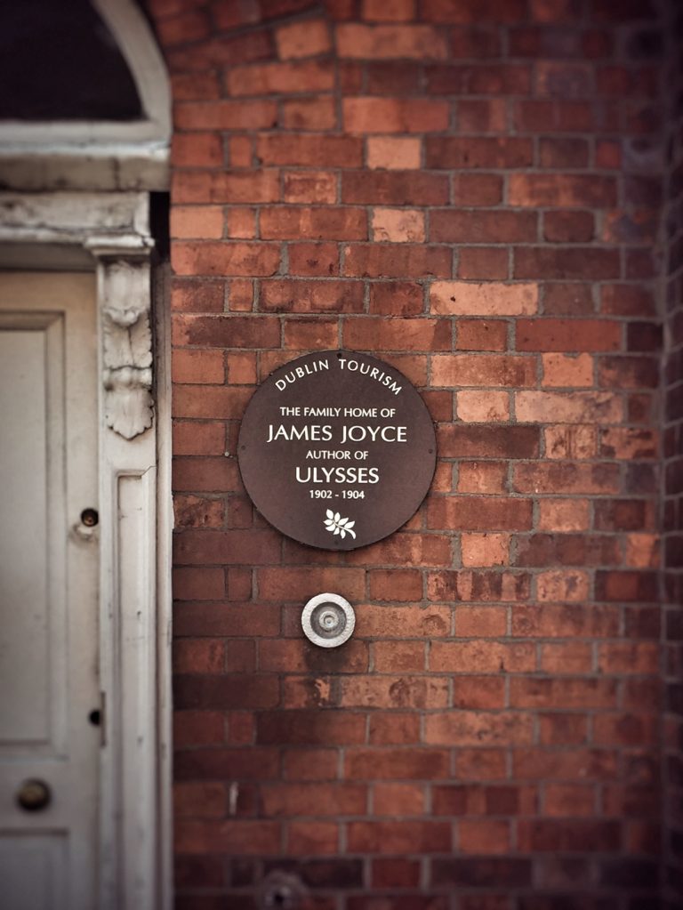
The general solution did not take long to figure out. The details did. I made a lot of trial runs and some walks, and at least one false start. I discovered pubs along the way, all of which had to be avoided and led to some contortions of the route, but the route is largely linear and directly links the two points. Bloom undergoes a lot more diverse wanderings and covers more distance on the 16th June 1904.
In devising the route the first thing to avoid is nearly all corners. To paraphrase an old joke, Why did Ireland never win the World Cup? Because every time they got a corner they opened a pub. You cannot avoid all corners, but you can avoid large junctions such as the main one in Phibsborough.
In the route descriptions I have used present day street names. It was very common for names of streets and house numbers to be changed in Dublin. I have noted several in the text.
I have used various Thom’s directories for historical information. Thom’s produce an almanac every year with information on residents and businesses in Dublin, amongst other facts. Generally I used the Thom’s of 1905, as its publication date is December 31st 1904, and its contents reflect locations in 1904. The directories are available to read in the Dublin City Library and Archive, 138-144 Pearse Street, Dublin 2. D02 HE37.
I have referred to Roger Norburn’s A James Joyce Chronology for key dates.
In the descriptions below I have made reference to present day and historic Ordnance Survey digital maps on www.osi.ie and maps.osi.ie. I have referred to the Historic Map 25 inch set from 1888 – 1913, which show the layout of the city that most closely matches the layout of 16th June 1904. Google Street View and Apple Maps are useful tools.
Nothing compares to going out and seeing the city on foot.
In 1904, addresses in Phibsborough are listed in the County Dublin Directory. The 1908 directory notes that Phibsborough has been amalgamated with the City of Dublin and in 1909 the streets of Phibsborough are listed in the City of Dublin Street Directory.
So the run begins outside of Dublin, as defined in 1904.
The Joyce family moved to 7 St. Peter’s Terrace Cabra on October 24th 1902. Norburn (p. 12)
Thom’s directory of 1903 (p.1738), 1904 (p.743) and 1905 (p.1799) list a John Joyce, James’s father as living at 7 St. Peter’s Terrace Cabra.
In the 1906 edition of Thom’s there is no St. Peter’s Terrace, as it appears to have been amalgamated into the listing for St. Peter’s Road. And there is no John Joyce living on the road.
We depart, as did James Joyce, in our case heading north.
Neither Shandon Street nor Shandon Park appear in the 1904 and 1905 editions of Thom’s and were most likely open fields. The first houses of Shandon Road can be seen in the 25 inch Ordnance Survey Map (1888 – 1913), with the first listings beginning in Thom’s of 1915.
The open land is probably the location where “He drives his beasts above Cabra” from the poem Tilly is set.
A short distance to the north of Shandon Park is the Royal Canal Towpath, accessed through a laneway and a small park.
The route goes east along the Royal Canal partly because it is pleasant but also to avoid Smith’s pub on Phibsborough Road. The surroundings are little changed from 1904.
It crosses Phibsborough Road at Cross Gunn’s Bridge, crossing Paddy Dignam’s funeral route, close to its end at Glasnevin Cemetery.
There is a major change when Royal Canal Bank turns south. The canal has been filled in and is now a road. Bloom would have had to cross the canal at Blacquiere Bridge on the North Circular Road. So the route follows the line of the former canal before turning east on North Circular Road.
This is a busy road with commercial activity and it may be that there was a pub in this location in 1904. Thom’s of 1904 lists a butcher a chemist and a draper amongst others, but as far as I can see, no public house (p.1606).
Much of the layout of roads is the same as in 1904 and the route passes the rear of the original Mater Hospital. Bloom could have easily come this way from his house on nearby Eccles Street.
The route turns into Glengarriff Parade, passing close to another of Joyce’s residences, 32 Glengarriff Parade. Just as 7 Saint Peter’s Terrace became 5 Saint Peter’s Road. 32 Glengarriff Parade is now 10 Glengarriff Parade. The route passes both houses.
Karl Whitney writes amusingly about this and all of Joyce’s Dublin residences in his book Hidden Dublin, Adventures and Explorations in Dublin.
Inisfallen Parade is a long straight road that runs down to Dorset Street. Thom’s has little to say about it. 89 small houses (p.1568).
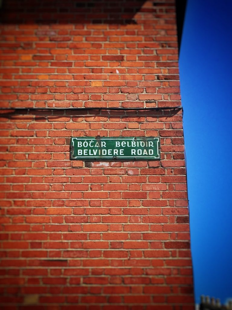
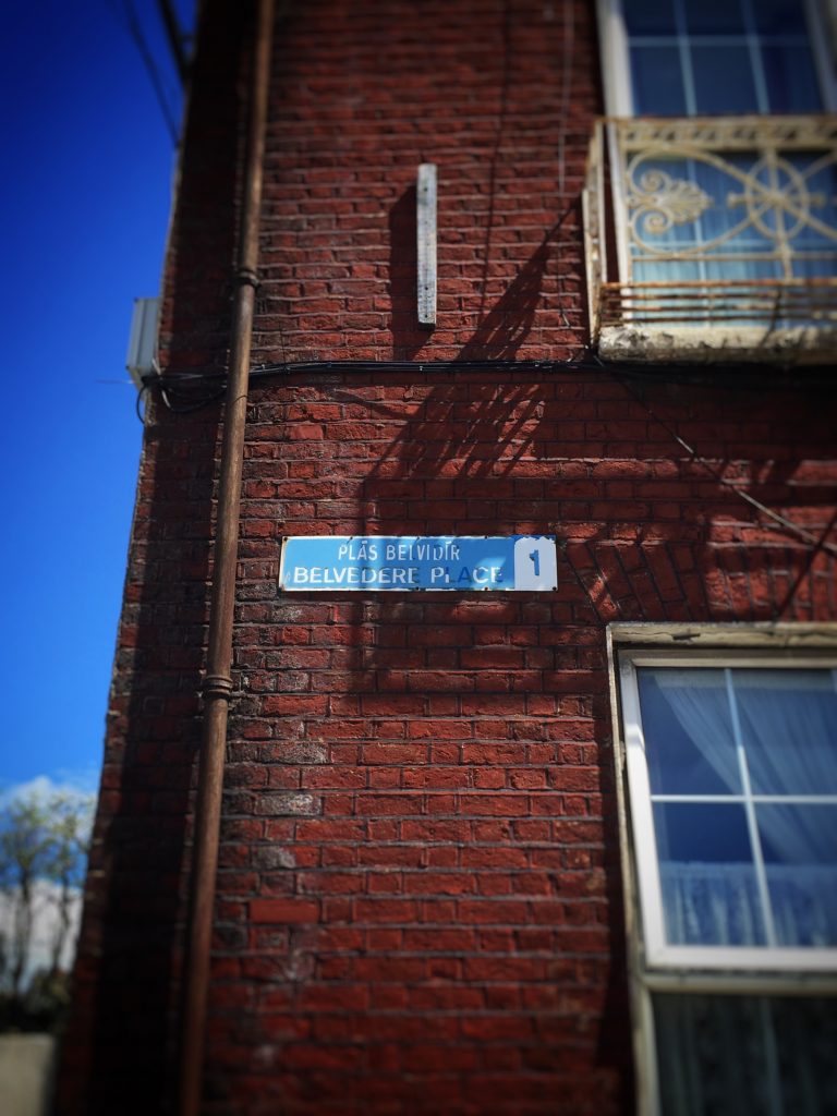
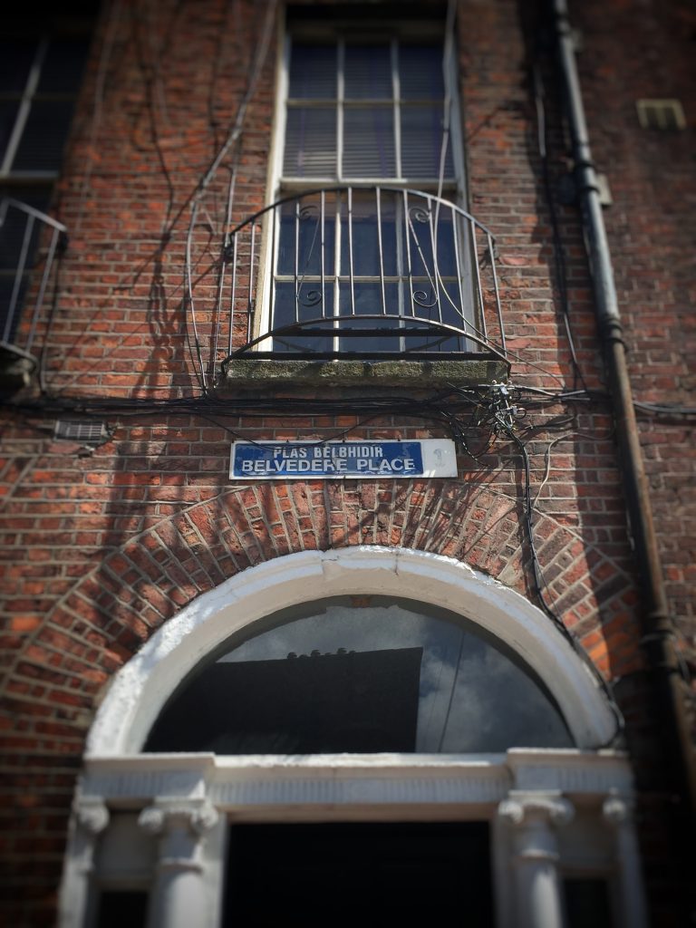
Crossing Dorset Street you continue along Belvidere Road. The more common Dublin spelling is Belvedere. The Ordnance Survey have Belvidere Road leading to Belvidere Place on both the modern and historical mapping, whereas Google Maps have Belvidere Road leading to Belvedere Place, as do the street signs. Apple Maps have Belvedere Road leading to Belvedere Place. Thom’s lists Belvidere-place and Belvidere-Road. Things get more confusing as gaelige, where Belvedere is spelt Belbidír, Belvidír and Belbhidir as you can see in the photographs below.
It’s not just Finnegans Wake that plays with language.
Time to move on.
Joyce went to the nearby Belvedere College and does not mention Belvedere Road or Belvedere Place in his texts. But it is known that he did visit the house of David Sheehy M.P., whose wife approaches the very reverend John Conmee S. J. on Mountjoy Square in the Wandering Rocks episode of Ulysses (p.180). David Sheedy and a Miss Sheedy, elocutionist, are listed in Thom’s as living in the house at 2 Belvidere-Place (p.1470).
The route passes the junction of Mountjoy Square East with Fitzgibbon Street, where Joyce lived in 14 Fitzgibbon Street, now number 34, and past the site of the postbox that Fr. Conmee gets Master Brunny Lynam to post the letter into in Ulysses (p.181). The postbox is no longer there. The postbox is listed as a Pillar Letter-Box in Thom’s (p.1470), and it can be seen as a dot on the ordnance survey map of the time.
Vivien Igoe in James Joyce’s Dublin Houses & Nora Barnacle’s Galway (p.50,51) writes of the meeting between Fr. Conmee and John Joyce on the corner of the square, leading to Joyce studying in Belvedere College without having to pay fees.
The meeting is fictionalised in A Portrait of an Artist as a Young Man (p.62)
—I walked bang into him, said Mr Dedalus for the fourth time, just at the corner of the square.
—Then I suppose, said Mrs Dedalus, he will be able to arrange it. I mean about Belvedere.
—Of course he will, said Mr Dedalus. Don’t I tell you he’s provincial of the order now?
—I never liked the idea of sending him to the christian brothers myself, said Mrs Dedalus.
—Christian brothers be damned! said Mr Dedalus. Is it with Paddy Stink and Mickey Mud? No, let him stick to the jesuits in God’s name since he began with them. They’ll be of service to him in after years. Those are the fellows that can get you a position.
—And they’re a very rich order, aren’t they, Simon?
—Rather. They live well, I tell you. You saw their table at Clongowes. Fed up, by God, like gamecocks.
As the route moves into Greville Street it crosses over the route that Bloom and Stephen Daedalus traveled on their way northwards to 7 Eccles Street after their trip to the cabmans shelter in the Eumaeus episode of Ulysses.
Thom’s lists D’Oli, Eugene Jermon, family grocer and wine merchant (p.1558) as being located on the corner of Hill Street and Greville Street, but again, not necessarily a public house and not listed separately as such in Thom’s.
In Hill Street the run passes the tower of Little St. George’s, the bells from which were moved from Hill Street to the new St. George’s in Hardwick Place.
The bells are heard pealing repeatedly Heigho, heigho, in Ulysses. They are heard by Bloom in the morning and by Stephen Daedalus and Bloom on the doorstep of 7 Eccles Street (p.578) when they return after their adventures in Nighttown, where the bells form one of the characters in the Circe episode (p.384).
We cross Parnell Street, which in 1904 was Great Britain Street North and go directly into North Cumberland Street.
There are no pubs on these corners today, nor as far as I can see in Thom’s, in 1904.
Sean Mac Dermott Street was originally Upper Gloucester Street, renamed like many streets after Irish patriots. The route heads north east again along the street, before crossing Gardiner Street and continuing to Gloucester Place Lower.
The route is now in one of the areas of the city that has most changed the most since Joyce’s time in Dublin. We are in the former Nighttown, prominently featured in the Circe episode of Ulysses. A haven of brothels and slums, largely obliterated, replaced by Corporation houses and offices.
Railway Street was originally Tyrone Street Lower, where Bella Cohen the brothel keeper lived at number 82. She lived at the eastern side of Tyrone Street Lower, towards Buckingham Street. We head in the opposite direction towards Mabbot Lane.
If we continued straight on we would be in James Joyce Street, formerly Mabbot Street.
The centre of Dublin is a concentration of pubs, so to avoid many of them the route goes down Mabbot Lane going by a series of lanes towards the back of the Custom House. Thom’s lists carriage builders and stores as the laneway’s main uses in 1904 (p.1585).
Moland Place is not listed separately in Thom’s, but the intersection with Talbot street is. there were no pubs here in 1904. It is at the southern end of Moland Place that the route comes closest to a pub. It runs down the side of one, but the gable end of the pub has no entrance or windows onto Moland Place.
This lane takes the route back to Gardiner Street, passing under the Loopline Railway Bridge for the first time. Thom’s lists Frenchman’s Lane as being free of Public Houses, though a wine bar has recently opened up, a few evenings a week.
The route goes south and to the western side of the Customs House, passing where Stephen and Bloom begin their walk back to 7 Eccles Street, passing Gumley minding stones for the Corporation in Ulysses (p. 112, 539).
We pass under a different section of the Loopline Bridge passing the former site of the cabman’s shelter from the Eumaeusepisode of Ulysses.
In Joyce’s time the Loopline Bridge was the most easterly bridge on the River Liffey with downstream crossings happening by Ferry. Bridge crossings with concentrated footfalls attract even more pubs and it is necessary to run east along the front of the Custom House and cross by the Matt Talbot bridge to avoid them.
Up until this point the route layout has been on roads and paths that existed in 1904. But we now cross over a new bridge. This proves that this route could not have been used by Bloom in 1904.
We cross over Anna Livia Plurabelle.
The new development at City Quay has changed much of the street layout and the route has to go along the quays to avoid pubs placed in and around it.
*By lorries along sir John Rogerson’s quay Mr Bloom walked soberly, past Windmill lane, Leask’s the linseed crusher, the postal telegraph office. Could have given that address too. And past the sailors’ home. He turned from the morning noises of the quayside and walked through Lime street. Ulysses (p.58)
As Bloom turns southwards from the quays into Lime Street, so do we.
Bloom goes west at this point, but we go east, heading towards Ringsend Village.
We turn south into Macken Street, formerly Great Clarence Street.
We turn eastwards along Pearse Street, formerly Great Brunswick Street, heading to Ringsend, in the opposite direction to Paddy Dignam’s funeral procession in Ulysses.
Thom’s lists Ringsend (p.1833) as being in the County Dublin Directory, so having crossed over the bridge we have finally crossed Dublin.
The route turns south just before Tunney’s pub, now the Oarsman, in Ringsend Village. Tunney’s is mentioned several times in Ulysses, as a grocer’s frequented by Gerty MacDowell (p.291) and a pub favoured by Paddy Dignam (p.207).
The route passes the field where the boys have An Encounter in Dubliners and past the plaque on the wall commemorating the Swan River, mentioned in Finnegans Wake. You can read more about this section in a previous blog post here
At this point the route is close to where Paddy Dignam’s funeral departed for Glasnevin, from 8 Newbridge Avenue, which is a short distance to the east. We go in the opposite direction along Lansdowne Road.
We are now back in the city with Shelbourne Road and Lansdowne Road listed as such in Thom’s.
The last turn is north onto Shelbourne Road, finishing shortly thereafter, to the endpoint at number 60, identified, as is the house on St. Peter’s Terrace, with a commemorative plaque.
Joyce rented a room from a Mrs. McKernan where he lived here from April to August 1904, departing to stay briefly at 35 Strand Road (Norburn p.20) on the night of 16th June 1904, the day on which Ulysses is set.
The solution only works in the present day. Whilst it generally follows a route available in 1904, it crosses a bridge that was not in existence and passes some locations where pubs were almost certainly present at that time.
The route does not pass any present day pubs, but it does pass a wine bar. The wine bar only opens three nights a week and is hardly a public house. Anyway it’s my game, and to an extent, these are my rules.
I have not solved the puzzle for the time in which it was set, 1904. It can possibly be solved for 1904, but not by using this route. The following establishments were located along the route and are listed in the 1905 Thom’s Directory.
“Fogarty, P., grocer, tea, wine and spirit merchant” at number 35 Hill Street (p.1550).
“McEvoy, Michael, wine merchant and bonder of whiskey” at number 13, North Gloucester Street (p.1551).
“Smyth, Patrick, grocer and spirit merchant” at number 24 City Quay.(p.1499)
But are they public houses? Thom’s lists the following categories of alcohol vendors separately:
Spirit Dealers
Taverns and Inns
Vintners and Publicans
Wine and Spirit Merchants
It is difficult to know the exact difference between all of the categories. But Davy Byrne’s, perhaps the most famous Public House in Ulysses is listed as David Byrne, a wine and spirit merchant under the listing for Duke Street (p.1526) . He also appears in the wine and spirit dealers lists. So a wine and spirit dealer can be a public house.
P. Fogarty of Hill Street and Smyth of City Quay do not appear in any of the alcohol vendor categories. But Michael McEvoy of North Gloucester Street appears as a wine merchant and bonder of whiskey. His premises are located on a corner and it was probably a busy public house.
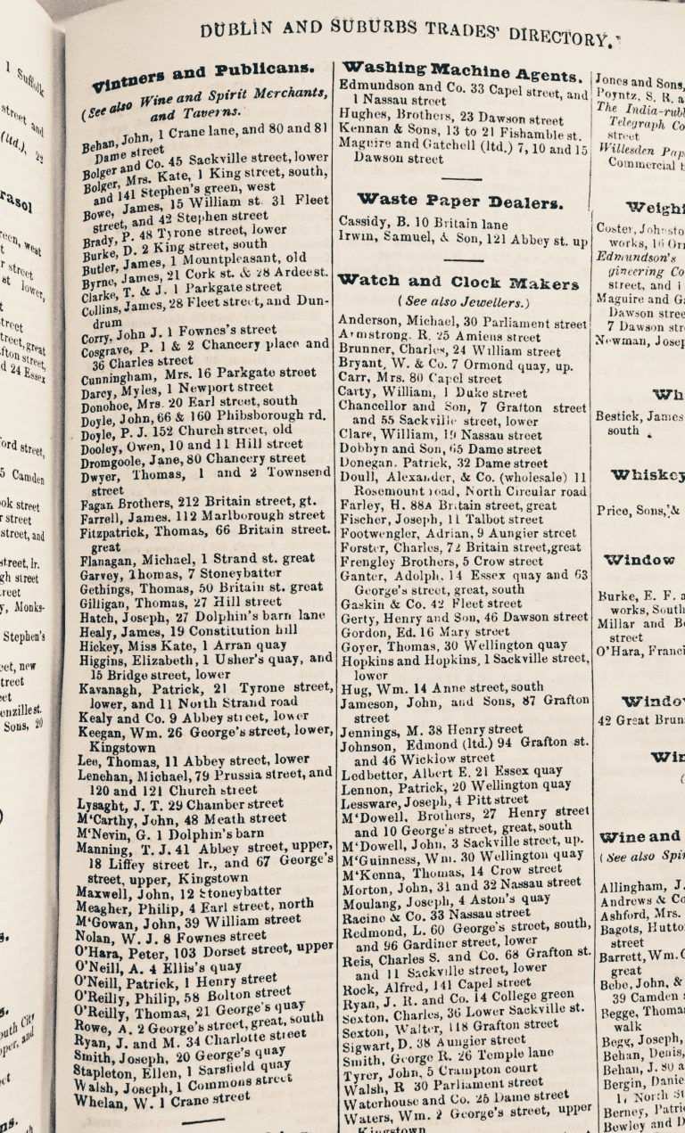
Some of these obstacles can be overcome by minor route changes. The puzzle will not be solved until you can prove that Dublin could be crossed without passing a pub in 1904, something that is the subject of my further research. My initial conclusions are that Bloom was probably right, you couldn’t cross Dublin without passing a pub.
But as has been noted, why bother? A simple solution to cross Dublin without passing a pub is simply to go into all of them.
You can look at this 21k route on Map My Run here.
You can download a GPX or KML file of the route from Map My Run.
Igoe, V. (2006) James Joyce’s Dublin Houses and Nora Barnacle’s Galway. Dublin, Ireland: Lilliput Press.
Joyce, J. (1998) Ulysses. Edited by Hans Walter Gabler, Wolfhard Steppe, and Claus Melchior. Afterword by Michael Gordon edn. New York, United States: Vintage Books.
Joyce, J. (2007) A Portrait of the Artist as a Young Man, Authoritative Text, Backgrounds and Contexts Criticism. Edited by John Paul Riquelme, Hans Walter Gabler, and Walter Hettche. New York, United States: Norton, W. W. & Company.
Norburn, R. (2004) A James Joyce Chronology. London, United Kingdom: Palgrave Macmillan.
Thom’s & Co. (Limited) (1902) Thom’s Official Directory of the United Kingdom of Great Britain and Ireland for the Year 1903. Dublin, Ireland: Alex. Thom’s & Co. (Limited)
Thom’s & Co. (Limited) (1903) Thom’s Official Directory of the United Kingdom of Great Britain and Ireland for the Year 1904. Dublin, Ireland: Alex. Thom’s & Co. (Limited)
Thom’s & Co. (Limited) (1904) Thom’s Official Directory of the United Kingdom of Great Britain and Ireland for the Year 1905. Dublin, Ireland: Alex. Thom’s & Co. (Limited)
Whitney, K. (2014) Hidden City: Adventures and Explorations in Dublin. Dublin, Ireland: Penguin Ireland.
http://www.kindle-maps.com/blog/how-to-walk-across-dublin-without-passing-a-pub-full-publess-route-here.html. Accessed May 16th, 2016
http://maps.osi.ie/publicviewer/#V2,578432,756724,0,10. Accessed May 16th, 2016